- Ski.com Home
- Blog
- Atmospheric River To Deliver Over 100 Inches Of Snow To Areas Of Tahoe
Atmospheric River To Deliver Over 100 Inches Of Snow To Areas Of Tahoe

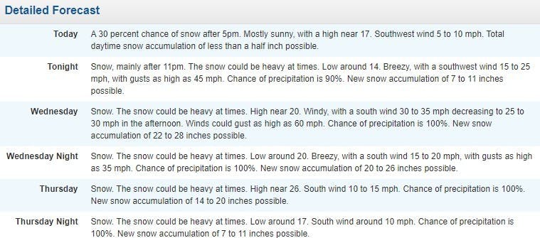
An atmospheric river is primed and pointed directly at the mountains of the Sierra Nevada and by the end of the weekend, high elevations could see upwards of 100 inches of fresh snow. Yes, you read that right... 100 INCHES OF FRESH POWDER.
Related: Reserve your spot on the mountain this season with RSVP – Refundable Ski Vacation Packages
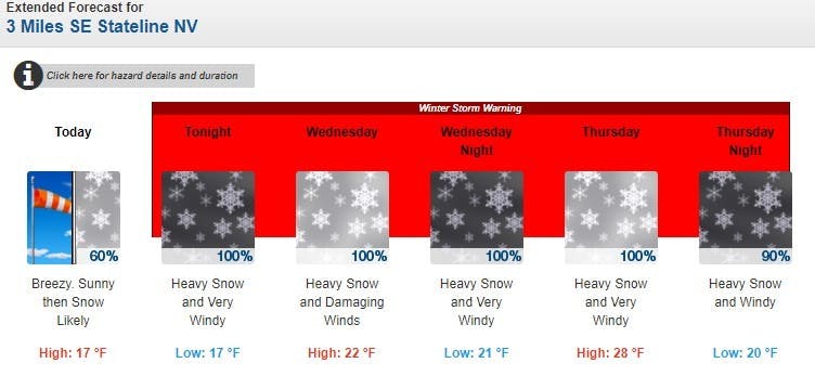
The storm should begin delivering snowfall this evening and things won't let up until late Thursday evening. Right now, the mountains on the South Shore of Lake Tahoe and further south are projected to see the largest snowfall totals so look for Kirkwood and Mammoth to be big winners when the storm begins to clear out on Sunday. Squaw Valley should pull down anywhere from 30-40 inches. In terms of snow levels, things will begin warm with only the high elevations of the Sierra seeing snow today and into this afternoon while the lower elevations see a rainy and wintry mix. That is all before temps drop along with the snow line to lake level this evening, where it should stay for the rest of the week. Translation: blower powder, no Sierra cement.
Let It Snow!
https://twitter.com/NWSSacramento/status/1354081668794093574
Squaw Valley Forecast:


Heavenly Forecast:
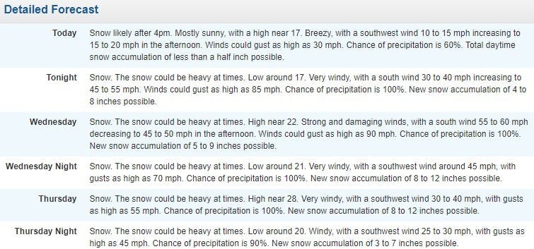
Mammoth Mountain Forecast:
Winter Storm Warning [NOAA]
...WINTER STORM WARNING REMAINS IN EFFECT FROM 7 PM THIS EVENING TO 4 AM PST FRIDAY...
* CHANGES...Yesterday`s Winter Weather Advisory has expired and was removed from the headline above.
* WHAT...For the Winter Storm Warning, heavy snow expected. Total snow accumulations of 1 to 3 feet, except 3 to 6 feet above 7000 feet. Winds gusting up to 45 mph in lower elevations and in excess of 90 mph over ridges leading to whiteout conditions.
* WHERE...Greater Lake Tahoe Area.
* WHEN...From 7 PM this evening to 4 AM PST Friday.
* ADDITIONAL DETAILS...Rough conditions can be expected on Lake Tahoe through much of the week. Gusts 30-45 mph with wave heights of 2 to 5 feet.
* IMPACTS...Travel could be very difficult to impossible tonight through Friday morning. Very strong winds could cause tree damage and power outages. If you risk travel over the Sierra passes, you cloud be stuck in your car for several hours.
https://twitter.com/NWSSacramento/status/1354061086043979777
Get ready for fresh tracks. Ski.com’s Mountain Travel Experts are here to help you plan and book everything for the perfect ski vacation. Call 800-610-8911 or fill out a brief form to receive a quote in your inbox >>.
TAGGED: atmospheric river, long-range forecast, noaa, stoke-worthy snow, palisades tahoe, weather
Barclay Idsal
Author
Latest blogs
View AllHow Our Free White (Ski) Glove Service Works:
Reach out to a Ski.com Mountain Travel Expert by phone, chat, or our online form. Share details about your group size, interests, and budget and your Expert will begin to craft your dream ski vacation.
Get a curated proposal with personalized suggestions from your Expert via email. Book directly online or request additions or revisions from your Expert until it’s perfect.
If you have questions, want to add or modify your reservations or need anything assistance, your Expert is always by your side to help before, during and after your trip.
Sign up for our newsletter
Sign up for exclusive offers, news, updates and more.


