- Ski.com Home
- Blog
- Blizzard Warning For Mammoth Mountain With Mind-Boggling Totals Forecasted
Blizzard Warning For Mammoth Mountain With Mind-Boggling Totals Forecasted

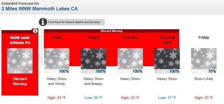
There is currently a Blizzard Warning in effect for Mammoth Mountain and today is officially a down day as most of the chairlifts on the mountain are on pause due to gale-force winds and white-out conditions. As part of the Blizzard Warning, The California Department of Transportation is recommending drivers avoid all Sierra Mountain passes for the next day as the risk of getting stranded for "a day or more" remains a possibility.
BOOK LAST MINUTE: Reserve your spot on the mountain this season with RSVP – Refundable Ski Vacation Packages
The Blizzard Warning is also being accompanied by an Avalanche Warning that recommends backcountry travelers avoid all areas close to avalanche terrain as slides may run "long distances into mature forests, valley floors" and even "flat terrain."
"Total snow accumulations of 1 to 3 feet, except 3 to 7 feet above 8000 feet." - NOAA
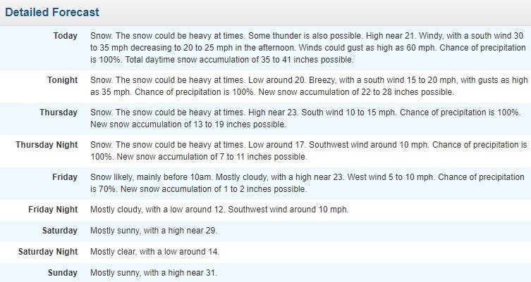
NOAA is currently forecasting upwards of 90 inches for portions of the upper mountain at Mammoth but much of that fresh snow may go unridden today and tomorrow as mountain operations work to mitigate avalanches throughout the skiable domain, dig out chairlifts, and clear access roads to the resort.
Mammoth Mountain Snow Report - 1/27/21
24 Hour - 19" | 72 Hour - 25" | Base Depth - 84" (mid-mountain)
IT’S DUMPING! As of 6AM we have picked up almost two feet of snow already. Today you can expect whiteout conditions throughout the day. A blizzard warning is in effect through Friday morning and operations will be very limited throughout this storm cycle. There are no operations expected out of Main Lodge today. Access to lodges is restricted at this time, expect wait times to access the lodges and plan to spend the majority of your time outdoors. Keep an eye on the lift status page for real-time operational updates throughout the day.
Forecast: Snow could be heavy at times. Some thunder is also possible. High near 21. Very windy, with a south wind 40 to 45 mph decreasing to 35 to 40 mph in the afternoon. Winds could gust as high as 70 mph. Chance of precipitation is 100%. Total daytime snow accumulation of 36 to 42 inches possible.
NOAA FORECAST: MAMMOTH MOUNTAIN


Blizzard Warning [NOAA]
...BLIZZARD WARNING REMAINS IN EFFECT FROM 10 PM THIS EVENING TO 4 AM PST FRIDAY...
* CHANGES...None.
* WHAT...Blizzard conditions expected. Total snow accumulations of 1 to 3 feet, except 3 to 7 feet above 8000 feet. Winds gusting as high as 55 mph in the lower elevations with gusts in excess 100 mph over the Sierra ridges at times creating whiteout conditions.
* WHERE...Mono County.
* WHEN...From 10 PM this evening to 4 AM PST Friday.
* ADDITIONAL DETAILS...There may also be periods of thundersnow tonight into Wednesday morning.
* IMPACTS...Travel could be near impossible or even paralyzed with near-zero visibility through Friday morning. Very strong winds could cause tree damage and power outages. If you risk travel over the Sierra passes, you cloud be stuck in your car for several hours, if not a day or more. Cold wind chills as low as 20 below zero could cause frostbite on exposed skin in as little as 30 minutes.
https://twitter.com/NWSSacramento/status/1354454234792529921
Get ready for fresh tracks. Ski.com’s Mountain Travel Experts are here to help you plan and book everything for the perfect ski vacation. Call 800-610-8911 or fill out a brief form to receive a quote in your inbox >>.
TAGGED: long-range forecast, mammoth mountain, aspen ski area, stoke-worthy snow, snowboard slopestyle, weather
Barclay Idsal
Author
Latest blogs
View AllHow Our Free White (Ski) Glove Service Works:
Reach out to a Ski.com Mountain Travel Expert by phone, chat, or our online form. Share details about your group size, interests, and budget and your Expert will begin to craft your dream ski vacation.
Get a curated proposal with personalized suggestions from your Expert via email. Book directly online or request additions or revisions from your Expert until it’s perfect.
If you have questions, want to add or modify your reservations or need anything assistance, your Expert is always by your side to help before, during and after your trip.
Sign up for our newsletter
Sign up for exclusive offers, news, updates and more.


