- Ski.com Home
- Blog
- The Cold Smoke Train Is Rolling Full Steam Towards The Rockies
The Cold Smoke Train Is Rolling Full Steam Towards The Rockies

Snow news is good news this week as a massive, two-segment storm has arrived in the Intermountain Rockies today and will continue to dump its payload through the President's Day Holiday. Right now, areas of Utah are projected to see some of their best powder days of the season, as are the resorts of Colorado. Other areas currently forecasted to see double-digit snow totals are the mountains of Oregon, Idaho, and Wyoming. The Sierra Nevada and Lake Tahoe should see decent totals, albeit smaller.
Related: Reserve your spot on the mountain this season with RSVP – Refundable Ski Vacation Packages
However, what's truly remarkable about this particular series of storm systems is the low temperatures that will accompany them. Thanks to an Arctic Blast coming in from the North Pole and a Pacific low-pressure system moving in from the northwest, the clashing systems will not only produce ample snowfall but it should be an extremely light powder as well. Often called "Cold Smoke," this type of snow that is usually reserved for Montana will be seen everywhere from Idaho to Colorado.
Let's take a look...
Ski.com President's Day Powder-Chase Picks:
Snowbird/Alta, UT
Jackson Hole, WY
Grand Targhee, WY
Park City, UT
Steamboat, CO
NOAA SHORT TERM FORECAST DISCUSSION:
https://twitter.com/NWSSaltLakeCity/status/1360263617447301122
...A series of winter storms to result in heavy snow accumulations from the Northwest to the Midwest this weekend...
The expansive dome of sub-freezing temperatures across the northern tier of the country has laid the foundation for winter storms to wreak havoc from coast-to-coast not only going into this weekend but also into next week. Today, periods of snow will blanket portions of the Northwest, the Intermountain West, and Midwest. The heaviest snowfall is anticipated in the Cascades, Tetons, and Colorado Rockies with accumulations over a foot possible. While lesser totals would occur in parts of the Northwest and central Plains, totals of 3 to 6 inches could lead to hazardous travel conditions. This has resulted in the issuance of Winter Weather Advisories and Winter Storm Warnings in these areas. By Saturday, a Pacific storm system slamming into the Pacific Northwest generates heavy snow and ice accumulations from Portland to Seattle. Pacific moisture out ahead of the storm system reaches the Sierra Nevada, Great Basin, and Intermountain West where periods of heavy mountain snow are likely. Hazardous travel conditions by both ground and air are expected in these areas into the upcoming weekend.
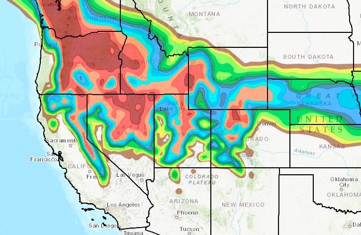 Forecast Radar for Sunday, 2/14/21 | Image: NOAA
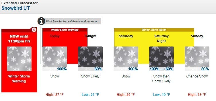
Snowbird, UT:
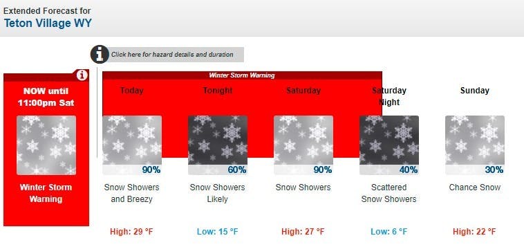
Jackson Hole, WY:
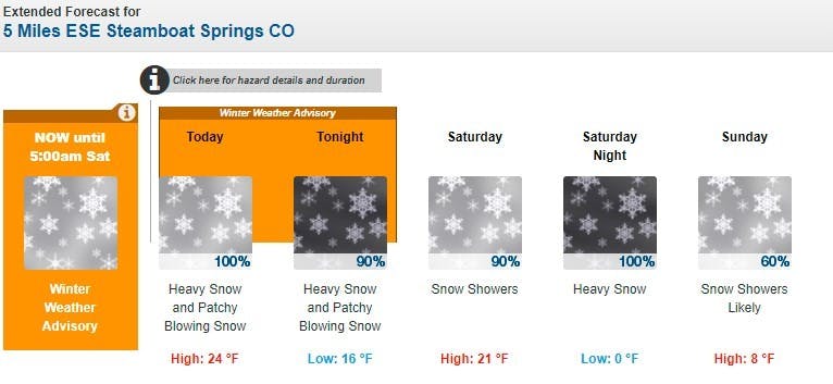
Steamboat, CO:
LET IT SNOW!
Get ready for fresh tracks. Ski.com’s Mountain Travel Experts are here to help you plan and book everything for the perfect ski vacation. Call 800-610-8911 or fill out a brief form to receive a quote in your inbox >>.
TAGGED: arctic blast, long-range forecast, Powder, aspen ski area, stoke-worthy snow, snowboard slopestyle, weather
Barclay Idsal
Author
Latest blogs
View AllHow Our Free White (Ski) Glove Service Works:
Reach out to a Ski.com Mountain Travel Expert by phone, chat, or our online form. Share details about your group size, interests, and budget and your Expert will begin to craft your dream ski vacation.
Get a curated proposal with personalized suggestions from your Expert via email. Book directly online or request additions or revisions from your Expert until it’s perfect.
If you have questions, want to add or modify your reservations or need anything assistance, your Expert is always by your side to help before, during and after your trip.
Sign up for our newsletter
Sign up for exclusive offers, news, updates and more.


