- Ski.com Home
- Blog
- Heavy Snow To Blanket PNW and East Coast | Up To 6 FEET For Mt Baker!
Heavy Snow To Blanket PNW and East Coast | Up To 6 FEET For Mt Baker!

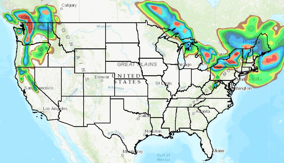 Forecast radar for 12/19/19 | Image: NOAA
After a very snowy week in Colorado, the focus this week shifts to Canada, the Pacific Northwest, and New England as two systems will bring bountiful powder to both coasts this week.
Related: Announcing The New Hires For The 2020 Ski.com Dream Job
Today, the snow is falling in earnest across the mountains of New York, Vermont, New Hampshire, and portions of western Maine. A Winter Weather Advisory is currently in effect with anywhere between 3-6" forecasted by this evening for portions of Southern Vermont. Look for ski areas such as Mount Snow and Okemo for the biggest snowfall totals.
In the Western USA and specifically the Pacific Northwest, expect biblical snowfall to cover the ski areas of Washington, Oregon, and coastal British Columbia including but not limited to Whistler Blackcomb, which could see over a foot by Friday.
https://twitter.com/NWSSeattle/status/1206983952461774848
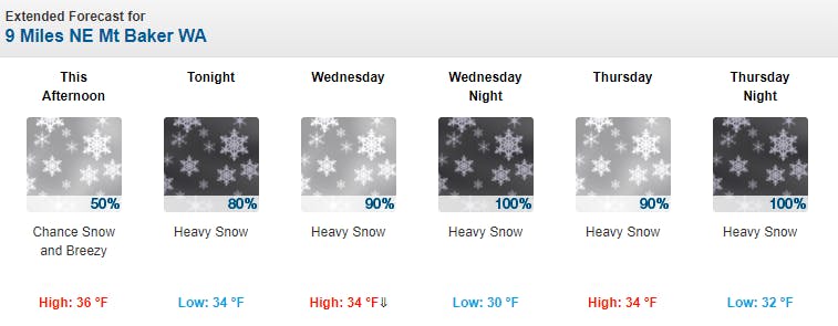
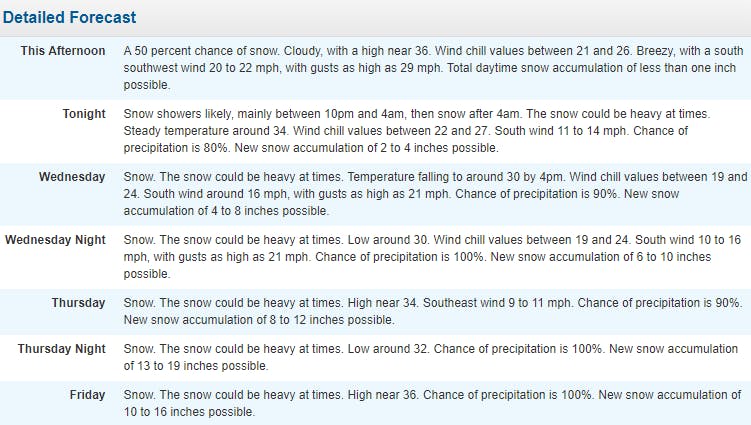
At Mt Baker Ski Area, NOAA is currently forecasting upwards of 70" of snow (almost 6 feet) by Friday evening. Further south at Mt Bachelor, snow totals could reach upwards of 30" by Saturday morning. All that powder will offer some much needed relief for the snow-starved ski populations of Portland and Seattle, both of which have been itching to get on the hill since November.
Mt Baker Forecast:
Hydrologic Outlook [Pacific Northwest]
Snow levels will begin around 3,000 feet but will rise to around 5,500 feet by late Thursday into Friday. The timing of the increase in snow levels, as well as the location where the heaviest precipitation sets up, will impact the degree of flooding at particular locations. Nonetheless, these rainfall amounts are likely sufficient to lead to flooding impacts on several area rivers by the weekend, and some of these impacts could be widespread or significant.
Mount Snow Forecast:
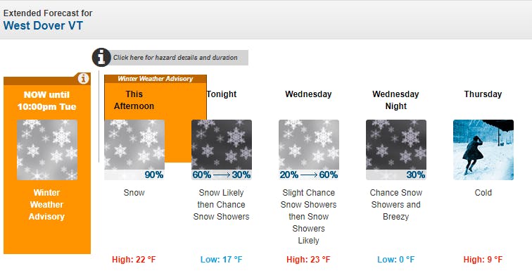
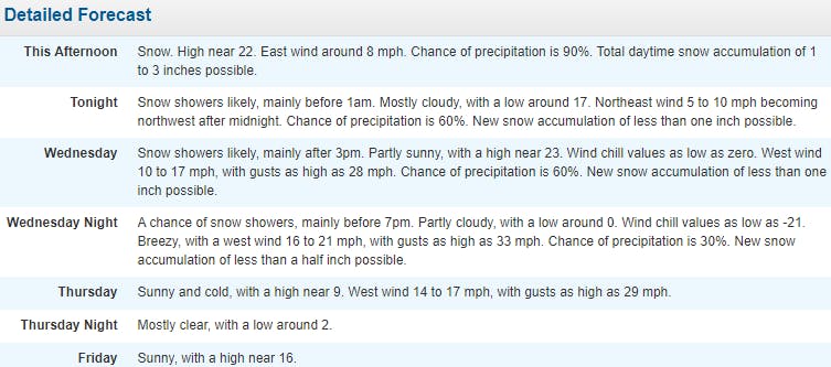
Winter Weather Advisory [New England]
...WINTER WEATHER ADVISORY REMAINS IN EFFECT UNTIL 10 PM EST THIS EVENING...
* WHAT...Snow. Storm total accumulation of 3 to 6 inches.
* WHERE...Mohawk Valley, Schoharie Valley, Helderbergs, Capital Region, Glens Falls and Saratoga Springs areas, northern and Central Taconics, southern Vermont and the northern Berkshires.
* WHEN...Until 10 PM EST this evening. The bulk of the snow accumulation will be done by 6 PM.
* IMPACTS...Plan on slippery road conditions and low visibility. The hazardous conditions will impact the evening commute.
TAGGED: long-range forecast, mount snow, Mt. Bachelor, okemo, PNW, stoke-worthy snow, weather, Whistler
Barclay Idsal
Author
Latest blogs
View AllHow Our Free White (Ski) Glove Service Works:
Reach out to a Ski.com Mountain Travel Expert by phone, chat, or our online form. Share details about your group size, interests, and budget and your Expert will begin to craft your dream ski vacation.
Get a curated proposal with personalized suggestions from your Expert via email. Book directly online or request additions or revisions from your Expert until it’s perfect.
If you have questions, want to add or modify your reservations or need anything assistance, your Expert is always by your side to help before, during and after your trip.
Sign up for our newsletter
Sign up for exclusive offers, news, updates and more.


