- Ski.com Home
- Blog
- NOAA: 2-3 Feet Forecasted Parts Of Colorado By Friday Evening!
NOAA: 2-3 Feet Forecasted Parts Of Colorado By Friday Evening!

 Forecast radar for Friday, 2-7-20 | Image: NOAA
The Pacific Northwest flow always delivers for the Vail Valley, so it's no surprise that NOAA is forecasting upwards of 2+ feet for the higher elevations of the Gore Range.
Related: All About Skiing Colorado In March
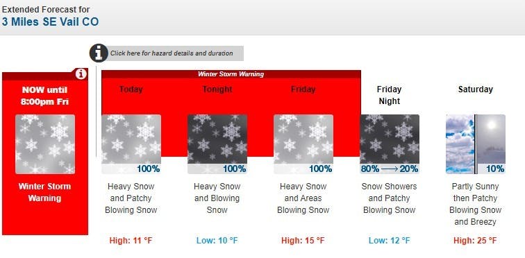
As of yesterday evening, Vail, Steamboat, Crested Butte, Aspen and Beaver Creek are all under Winter Storm Warnings and traction laws are in effect across Colorado. For those looking to travel to the mountains this weekend, early starts are highly recommended as road closures are expected to impact drive times.
https://twitter.com/NWSGJT/status/1225380598027390976
NOAA SHORT RANGE DISCUSSION:
A Pacific storm will progress across Northern and Central Colorado through Saturday. This system will bring a prolonged period of cooler and unsettled weather to the region with accumulating snow for the mountains as well as some higher valley locations.
The Elkhead, Park, Gore Ranges and Flat Tops will be favored for the heaviest snowfall, which will be measured in feet for some spots. Additionally, strong winds are expected with this system with wind gusts exceeding 45 MPH at times which may drop visibilities in a very short period of time.
Steamboat Forecast:


Vail Forecast:


Beaver Creek Forecast:


Aspen Forecast:


Crested Butte Forecast:


Winter Storm Warning [Northern Colorado]
...WINTER STORM WARNING REMAINS IN EFFECT UNTIL 9 AM MST SATURDAY...
* WHAT...Heavy snow expected. Total snow accumulations of 10 to 20 inches with locally higher amounts up to 3 feet. Winds gusting as high as 45 mph.
* WHERE...Elkhead and Park Mountains and Flat Tops.
* WHEN...Through 9 AM MST Saturday.
* IMPACTS...Travel will be very difficult to impossible, especially on mountain passes. Patchy blowing snow could significantly reduce visibility, especially on ridge tops. The
cold wind chills as low as 25 below zero could cause frostbite on exposed skin in as little as 30 minutes. A detailed map of the snowfall can be found at: www.weather.gov/gjt/winter.
Winter Storm Warning [Central Colorado]
...WINTER STORM WARNING REMAINS IN EFFECT UNTIL 8 PM MST FRIDAY...
* WHAT...Heavy snow expected. Total snow accumulations of 8 to 18 inches with locally higher amounts up to 2 feet. Winds gusting as high as 40 mph.
* WHERE...Gore and Elk Mountains/Central Mountain Valleys and West Elk and Sawatch Mountains.
* WHEN...Through 8 PM MST Friday.
* IMPACTS...Travel will be very difficult to impossible at times, especially on mountain passes. Patchy blowing snow could significantly reduce visibility. The cold wind chills as
low as 20 below zero could cause frostbite on exposed skin in as little as 30 minutes. A detailed map of the snowfall can be found at: www.weather.gov/gjt/winter.
Get ready for fresh tracks. Ski.com’s Mountain Travel Experts are here to help you plan and book everything for the perfect ski vacation. Call 800-610-8911 or fill out a brief from to receive a quote in your inbox >>
It takes 2 minutes.
TAGGED: Colorado, long-range forecast, Powder, stoke-worthy snow, weather
Barclay Idsal
Author
How Our Free White (Ski) Glove Service Works:
Reach out to a Ski.com Mountain Travel Expert by phone, chat, or our online form. Share details about your group size, interests, and budget and your Expert will begin to craft your dream ski vacation.
Get a curated proposal with personalized suggestions from your Expert via email. Book directly online or request additions or revisions from your Expert until it’s perfect
If you have questions, want to add or modify your reservations or need anything assistance, your Expert is always by your side to help before, during and after your trip.
Sign up for our newsletter
Sign up for exclusive offers, news, updates and more.
- Discounts
- Latest News

